The Cheyenne-Deadwood Stage
Between Cheyenne and Chugwater, modern day US-87/ Interstate-25 was once first loosely defined by the Cheyenne-Deadwood stage route before it went East just North of Chugwater towards Fort Laramie on modern day US-26. In November (1876) the Wyoming territorial legislature authorized the survey and designation of a road from Cheyenne via Chugwater Creek and Fort Laramie to Custer City. The firm of Gilman, Salisbury, and Patrick, awarded a monopoly in commercial transportation, pushed the construction of a chain of road ranches or stations, assembled personnel and equipment and, by March 1, 1876, their new line was in operation [...] The run to Custer City from Cheyenne was 180 miles, or 266 miles to Deadwood after that fabled gulch became the main attraction. The route from Cheyenne to Fort Laramie followed the Chugwater and Laramie Rivers where there was a series of road ranches. (National Park Service)
Learn More about Fort Laramie
National Park Service. "Chapter XIII: THE CHEYENNE-DEADWOOD STAGE ROAD." Fort Laramie NHS. 01 March, 2003. Fort Laramie NHS: Park History (Part I) (nps.gov)

This 1884 photograph shows the Cheyenne-Deadwood stage in front of the Swan Land and Cattle company (Image Platte County Library)

Dangers on the Road
A large part of our inherited imagery of "the Wild West" stems from the epidemic of crime along the Cheyenne-Deadwood Trail. Those who preyed on Black Hills travelers included unreconstructed Indians from the agencies, but most criminal activity was the work of white outlaws. Sometimes there was no way to tell whether a given atrocity was the handiwork of red man or white. While Indian strays killed mainly for revenge, the outlaws were bent on plain stealing, with their killings of company employees and passengers incidental to that main objective. The fine art of highway robbery reached a new peak in their assaults on armored stage-coaches with treasure-boxes of gold heading for Cheyenne. Fort Laramie cavalry patrols were frequently assigned to guard danger spots or track down criminals. Among incidents in the Fort Laramie neighborhood were several killings at the Three Mile Ranch, the lynching of horse-thieves by masked men just north of the iron bridge, and stage hold-ups along Laramie River. (National Park Service) (Painting by N.C. Wyeth)

The Park to Park Highway/ Yellowstone Highway
Before the US Highway System was implemented in 1926 what became US-185, (recommissioned as US-87 in the 1930s) was called the "Yellowstone Highway" from Denver, Colorado to Casper, Wyoming. It was later a part of the system called the "Park to Park Highway". (Image Platte County Archives)
Becoming US-87

Origins
When the US Highway System was implemented in 1926, US-87 Originally began in Rawlins and headed North on modern day US-287 where it split into an West route along modern day US-287 to Lander and East route along modern day WY-220 to Casper. (Image 1927 Rand McNally Map)

The Crown Jewel
Once able to claim itself as being a major route through Yellowstone National Park, US-87 W continued up through Dubois and Moran Junction along modern day US-287 where it followed modern day US-89 up to Gardiner, MT and further. (Image 1927 Rand McNally Map)

Little Change
When US-87E reached Casper on current day WY-220, it continued on much of its later alignment up to Armington Junction where it met up with the Western half of its route. (Image 1927 Rand McNally Map)

US-185
What became US-87 in the 1930s, until Interstate-25 took over from Cheyenne to Orin Junction, was originally signed as US-185 in 1926. At the time, US-20 carried motorists to Casper from Orin Junction to meet up with US-87E. US-185 was later dropped entirely as a signed route when US-87 was moved onto its right of way. (Image 1927 Rand McNally Map)

Rough Road
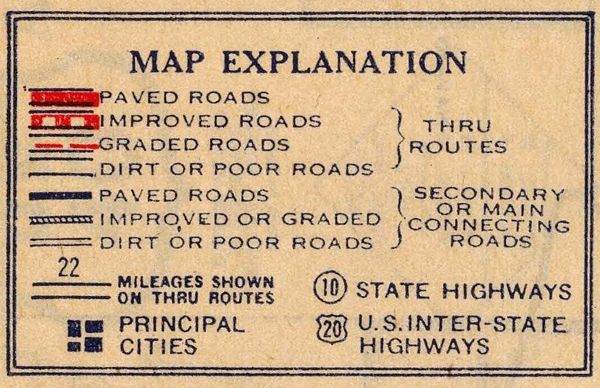
It's important to note in the legend of these early 1927 Highway maps that almost none of these roads were paved. They likely contained gravel and grading as indicated by being "Improved Roads" in the legend to the right, but were clearly not paved as indicated with a solid bar of red. (Image 1927 Rand McNally Map)
The Modern US-87

1937-Wyoming
Wyoming's US-87 as we know it came into existence in 1936 during a period of number revisions when US-287 also sprang up to take over the old route. However, by 1937, WY-220 had not yet been commissioned to take over the old US-87E route from Muddy Gap to Casper, which is still visible on this version. US-87 as it existed for most of the rest of its life until decommissioning in the 1970s is shown here in green. Local alignments changed slightly with road improvements. (Image 1937 Texaco Road Map)
Historic Route US 87
Copyright © 2023 Historic Route US 87 - All Rights Reserved.
Powered by GoDaddy
This website uses cookies.
We use cookies to analyze website traffic and optimize your website experience. By accepting our use of cookies, your data will be aggregated with all other user data.